![](/images/other/stat-length.png)
![Tocht Te voet Furth im Wald - Fu32 »Ränkamer Rundweg« (Furth im Wald) - Photo](https://media.geolcdn.com/t/1900/400/ext.pjpeg?maxdim=2&url=https%3A%2F%2Fstatic1.geolcdn.com%2Fsiteimages%2Fupload%2Ffiles%2F1545311037marcheuse_200dpi.jpg)
Fu32 »Ränkamer Rundweg« (Furth im Wald)
SityTrail - itinéraires balisés pédestres
Tous les sentiers balisés d’Europe GUIDE+
![Lengte](/images/other/stat-length.png)
Lengte
7,7 km
![Max. hoogte](https://static1.geolcdn.com/siteimages/upload/files/1508320355ic_sort_altitude_max_24dp.png)
Max. hoogte
496 m
![Positief hoogteverschil](https://static1.geolcdn.com/siteimages/upload/files/1508320355ic_sort_den_pos_24dp.png)
Positief hoogteverschil
165 m
![Km-Effort](/images/other/stat-length.png)
Km-Effort
9,9 km
![Min. hoogte](https://static1.geolcdn.com/siteimages/upload/files/1508320355ic_sort_altitude_min_24dp.png)
Min. hoogte
386 m
![Negatief hoogteverschil](https://static1.geolcdn.com/siteimages/upload/files/1508320355ic_sort_den_neg_24dp.png)
Negatief hoogteverschil
164 m
![Boucle](https://static1.geolcdn.com/siteimages/upload/files/16400158638029165_repeat_loop_refresh_sync_direction_icon.png)
Boucle
Ja
Markering
Datum van aanmaak :
2022-02-11 19:33:37.829
Laatste wijziging :
2022-02-11 19:33:37.829
![Te voet](https://static1.geolcdn.com/sitytour/trail-icons/100.png)
2h14
Moeilijkheid : Gemakkelijk
![Scan deze QR-code om de tocht te openen in de SityTrail-applicatie](https://capi.geolives.com/qq0zvz2zws4bq2lad0pu/sitytour/trails/3100819/qr.png?size=200)
Gratisgps-wandelapplicatie
Over ons
Tocht Te voet van 7,7 km beschikbaar op Beieren, Landkreis Cham, Furth im Wald. Deze tocht wordt voorgesteld door SityTrail - itinéraires balisés pédestres.
Beschrijving
Trail created by ARGE Further Wanderwege ??.
Symbol: Schwarze Wegnummer im weißen Bereich des oben weißen / unten roten, rechteckigen Hintergrunds
Plaatsbepaling
Land:
Germany
Regio :
Beieren
Departement/Provincie :
Landkreis Cham
Gemeente :
Furth im Wald
Locatie:
Unknown
Vertrek:(Dec)
Vertrek:(UTM)
339504 ; 5462357 (33U) N.
Opmerkingen
Wandeltochten in de omgeving
![Tocht Te voet Furth im Wald - Fu11 »Hammerschmiedeweg« (Furth im Wald) - Photo](https://media.geolcdn.com/t/375/260/cdbb5a43-9cac-40d7-b43c-e7a2012f82b2.jpeg&format=jpg&maxdim=2)
![Te voet Te voet](https://static1.geolcdn.com/sitytour/trail-icons/100.png)
Fu11 »Hammerschmiedeweg« (Furth im Wald)
Te voet
Gemakkelijk
Furth im Wald,
Beieren,
Landkreis Cham,
Germany
![](/images/other/stat-length.png)
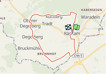
8,3 km | 10,7 km-effort
2h 25min
![](https://static1.geolcdn.com/siteimages/upload/files/16400158638029165_repeat_loop_refresh_sync_direction_icon.png)
Ja
![Tocht Te voet Furth im Wald - Fu05 Arnschwanger Weg - Photo](https://media.geolcdn.com/t/375/260/352f0aa5-db68-4e23-babc-b1d03c091cf4.jpeg&format=jpg&maxdim=2)
![Te voet Te voet](https://static1.geolcdn.com/sitytour/trail-icons/100.png)
Fu05 Arnschwanger Weg
Te voet
Gemakkelijk
Furth im Wald,
Beieren,
Landkreis Cham,
Germany
![](/images/other/stat-length.png)
8,8 km | 11,8 km-effort
2h 41min
![](https://static1.geolcdn.com/siteimages/upload/files/16400158638029165_repeat_loop_refresh_sync_direction_icon.png)
Neen
![Tocht Te voet Furth im Wald - Fu04 Steinbruchseeweg - Photo](https://media.geolcdn.com/t/375/260/457098b4-ffd5-4d32-ac88-228ffbf0283a.jpeg&format=jpg&maxdim=2)
![Te voet Te voet](https://static1.geolcdn.com/sitytour/trail-icons/100.png)
Fu04 Steinbruchseeweg
Te voet
Gemakkelijk
Furth im Wald,
Beieren,
Landkreis Cham,
Germany
![](/images/other/stat-length.png)
5,6 km | 7,8 km-effort
1h 45min
![](https://static1.geolcdn.com/siteimages/upload/files/16400158638029165_repeat_loop_refresh_sync_direction_icon.png)
Neen
![Tocht Te voet Furth im Wald - Fu03 Hohenbogenweg - Photo](https://media.geolcdn.com/t/375/260/3c4f947b-7ce4-437f-ba58-8a2d63e6bc8c.jpeg&format=jpg&maxdim=2)
![Te voet Te voet](https://static1.geolcdn.com/sitytour/trail-icons/100.png)
Fu03 Hohenbogenweg
Te voet
Moeilijk
Furth im Wald,
Beieren,
Landkreis Cham,
Germany
![](/images/other/stat-length.png)
21 km | 31 km-effort
7h 3min
![](https://static1.geolcdn.com/siteimages/upload/files/16400158638029165_repeat_loop_refresh_sync_direction_icon.png)
Ja
![Tocht Te voet Arnschwang - As03 (Kalkofenrundweg, Arnschwang) - Photo](https://media.geolcdn.com/t/375/260/352f0aa5-db68-4e23-babc-b1d03c091cf4.jpeg&format=jpg&maxdim=2)
![Te voet Te voet](https://static1.geolcdn.com/sitytour/trail-icons/100.png)
As03 (Kalkofenrundweg, Arnschwang)
Te voet
Gemakkelijk
Arnschwang,
Beieren,
Landkreis Cham,
Germany
![](/images/other/stat-length.png)
11,7 km | 16 km-effort
3h 38min
![](https://static1.geolcdn.com/siteimages/upload/files/16400158638029165_repeat_loop_refresh_sync_direction_icon.png)
Ja
![Tocht Te voet Arnschwang - As02 (Kapellenweg, Arnschwang) - Photo](https://media.geolcdn.com/t/375/260/352f0aa5-db68-4e23-babc-b1d03c091cf4.jpeg&format=jpg&maxdim=2)
![Te voet Te voet](https://static1.geolcdn.com/sitytour/trail-icons/100.png)
As02 (Kapellenweg, Arnschwang)
Te voet
Gemakkelijk
Arnschwang,
Beieren,
Landkreis Cham,
Germany
![](/images/other/stat-length.png)
4,7 km | 6,7 km-effort
1h 30min
![](https://static1.geolcdn.com/siteimages/upload/files/16400158638029165_repeat_loop_refresh_sync_direction_icon.png)
Neen
![Tocht Te voet Arnschwang - As01 (Sebastiansweg, Arnschwang) - Photo](https://media.geolcdn.com/t/375/260/352f0aa5-db68-4e23-babc-b1d03c091cf4.jpeg&format=jpg&maxdim=2)
![Te voet Te voet](https://static1.geolcdn.com/sitytour/trail-icons/100.png)
As01 (Sebastiansweg, Arnschwang)
Te voet
Gemakkelijk
Arnschwang,
Beieren,
Landkreis Cham,
Germany
![](/images/other/stat-length.png)
7,7 km | 10,3 km-effort
2h 19min
![](https://static1.geolcdn.com/siteimages/upload/files/16400158638029165_repeat_loop_refresh_sync_direction_icon.png)
Neen
![Tocht Te voet Furth im Wald - Fu09 »Dreiwappenweg« (Furth im Wald) inkl. Abkürzung - Photo](https://media.geolcdn.com/t/375/260/925a1e31-e6f2-4614-9e6b-da996f61c722.jpeg&format=jpg&maxdim=2)
![Te voet Te voet](https://static1.geolcdn.com/sitytour/trail-icons/100.png)
Fu09 »Dreiwappenweg« (Furth im Wald) inkl. Abkürzung
Te voet
Gemakkelijk
Furth im Wald,
Beieren,
Landkreis Cham,
Germany
![](/images/other/stat-length.png)
7,8 km | 13,3 km-effort
3h 1min
![](https://static1.geolcdn.com/siteimages/upload/files/16400158638029165_repeat_loop_refresh_sync_direction_icon.png)
Neen
![Tocht Te voet Furth im Wald - Fu42 »Voithenberger Rundweg« (Furth im Wald) - Photo](https://media.geolcdn.com/t/375/260/183129cc-755a-483b-b1af-bae713c54368.jpeg&format=jpg&maxdim=2)
![Te voet Te voet](https://static1.geolcdn.com/sitytour/trail-icons/100.png)
Fu42 »Voithenberger Rundweg« (Furth im Wald)
Te voet
Gemakkelijk
Furth im Wald,
Beieren,
Landkreis Cham,
Germany
![](/images/other/stat-length.png)
3,8 km | 5,8 km-effort
1h 18min
![](https://static1.geolcdn.com/siteimages/upload/files/16400158638029165_repeat_loop_refresh_sync_direction_icon.png)
Ja